Current approaches to vertical atmospheric profiling are limited in their temporal and spatial resolution, weather balloon-based sondes are rarely recovered leading to environmental harm and limited sensor capacity with launches happening in few locations across the UK radiosondes. This approach offers a fire and forget way to gather atmospheric profiles but is not in line with the desire to move towards a greener society. The University of Bristol while collaborating with the Met Office have been considering different approaches to gathering vertical profiles of atmospheric data with UAS with the eventual goal of replacing weather balloons and improving forecasting with increased data resolution and filling the data gap being experienced by meteorological services.
The main approach being considered focuses on using multirotor vehicles as a wind speed and direction sensor while also carrying other useful meteorological sensors such as temperature and humidity. Requirements to reach altitudes of at least 10,000ft and cope with higher wind speeds than might be seen at ground level led to the development of the Bristol University Drone Sonde (BUDS) a high altitude, high endurance multirotor. This vehicle was built with a significant thrust to weight ratio allowing for operations in high wind speeds and lower density atmospheres that could be experienced at higher altitudes.


By relating the state and control inputs of the vehicle to the outputs being experienced, the effect of wind speed on the system can be determined. This allows the vehicle to estimate the wind being experienced without the need for any weighty additional sensors. The models were built using a variety of methods, including flying alongside a sonic anemometer to directly relate the wind speed and body angle, using a wind tunnel to define the airframe drag and thrust under varying conditions, as well as building a model through aircraft flight manoeuvres.

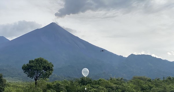
This work was taken to Volcan De Fuego in Guatemala where an area of airspace was given to the University of Bristol for high altitude Beyond Visual Line Of Sight (BVLOS) flights up to 18,000ft. The Bristol University Drone Sonde (BUDS) was flown up to 8,200ft Above Ground Level (AGL) to an altitude of 12,000 Above Mean Sea Level (AMSL) building a vertical profile of atmospheric wind conditions. This data was compared to a Windsond radiosonde to allow a comparison between the data gathered during the climb by BUDS and the current state of vertical profiling. Using UAS for this task we are also looking forwards to mapping 3D wind fields and how they develop over time and how this data can be used to improve the safety of UAS operations in future. This work was only made possible thanks to INSIVUMEH, DGAC, and Geo Travel Guatemala and their support for The University of Bristol Flight Lab. Also, thanks to the Met Office for their continued support with this work.